
4235 Monterey Road
Los Angeles, CA 90032
TRAILS
What makes a good trail? A good
trail matches its location, adjacent
resources, and the type of users
with the trail's purpose. There
are different types of trails for
different experiences. For
example, a nature trail does not
always serve as a hiking trail, and
a footpath is not always a good
place for bikes. In Debs Park,
 trails allow visitors the pleasure
of walking and hiking, enjoying
the views, and participating in nature interpretive programs. To use the trails, visitors
need only make a short-time commitment in order to "escape" to the sights and sounds of
nature, or to find spectacular views of the Los Angeles Basin.
trails allow visitors the pleasure
of walking and hiking, enjoying
the views, and participating in nature interpretive programs. To use the trails, visitors
need only make a short-time commitment in order to "escape" to the sights and sounds of
nature, or to find spectacular views of the Los Angeles Basin.
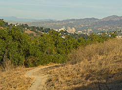
Existing and proposed trails, as well as potential habitat restoration sites are identified in Figure 8. Trails take a visitor to the existing picnic grounds, ball fields, and park interior, or in the future to the new Audubon Nature Center or the new restored pond. Existing trails consist of paved access roads; unpaved, engineered "fire" roads; and rugged trails or footpaths. Pedestrian entry points are located throughout the Park's perimeter, including from Via Marisol, Bushnell Way, and Griffin Avenue.
EXISTING TRAILS
The Summit View Trail leads from the main parking lot to the existing reservoir, then runs
northeast to the damaged gazebo, which may be replaced with new seating, and ends at a
small rest area. Paved for most of its length, this trail varies in slope from 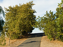 rather steep to
almost level. The Summit View Trail forms the backbone of the trail system following
the major ridgeline that bisects the park into its eastern and western slopes. In the future,
several benches will be installed along the trail to allow for resting during the climb and to
enjoy the surrounding landscape. The Summit View Trail also provides access to the
reservoir, the Lake View Trail, and to the City View and Walnut Forest Trails. Adjacent
to the paved Summit View Trail, on the east, is the unpaved Valley View Trail. This
alternative route to the reservoir is a footpath cut into the hillside affording an
opportunity for additional, more open views to the east. The Valley View Trail is often
damaged by discing of the hillside vegetation. The Plan recommends halting the
vegetation discing in this area, and maintaining the trail to reduce erosion.
rather steep to
almost level. The Summit View Trail forms the backbone of the trail system following
the major ridgeline that bisects the park into its eastern and western slopes. In the future,
several benches will be installed along the trail to allow for resting during the climb and to
enjoy the surrounding landscape. The Summit View Trail also provides access to the
reservoir, the Lake View Trail, and to the City View and Walnut Forest Trails. Adjacent
to the paved Summit View Trail, on the east, is the unpaved Valley View Trail. This
alternative route to the reservoir is a footpath cut into the hillside affording an
opportunity for additional, more open views to the east. The Valley View Trail is often
damaged by discing of the hillside vegetation. The Plan recommends halting the
vegetation discing in this area, and maintaining the trail to reduce erosion.
The Lake View Trail extends from the western edge of the main parking lot, forms part of a small loop trail around the pine tree plantation, and then climbs to the reservoir. Here, the Lake View Trail will connect with the future Pond Nature Trail, which will be improved to reduce erosion and provide access around a portion of the reservoir. Among trails, the favorite for finding panorama views is the City View Trail. This footpath trail cuts across the northwest slopes from Summit View Trail and connects with the Walnut Forest Trail. The City View Trail needs improvement to reduce erosion. Located on unpaved, improved roads that form a loop from east to west, the Walnut Forest Trail is well maintained, and suitable for leisurely walking or fast hiking. Cobblestone walls exist along the trail, adding a sense of history to the area.
Along the northern perimeter of the park, pedestrian access stems from the Oak Ridge Trail, the Seco View Trail, the Sycamore Trail, and the newly proposed Hummingbird Trail. All of these trails provide access to the Walnut Forest Trail, and in turn to the reservoir, and the interior and southern portion of the park. To the south of the main parking lot, is the Woodpecker Loop Trail. This trail is paved, encircling the main picnic grounds, and extending to the smaller secondary picnic area in the south.
PROPOSED TRAILS
To provide additional recreational opportunities and access in the southern portion of the
park, the Draft Framework Plan proposes the future establishment of two new unpaved
footpaths, the Rose Hill Trail, and the Roadrunner Trail. The Rose Hill Trail will form a
loop connecting the ball fields, the picnic areas, the main parking lot, and Lake View Trail.
On the southeast will be the Roadrunner Trail, a short loop surrounding the ball fields and
extending to the parkÕs southern boundary. In the future, these trails will link new
recreational uses in this part of the Park.
As briefly described earlier in the Plan, a nature trail is planned for the reservoir site upon completion of its habitat enhancement program. The nature trail, to be called the Pond Nature Trail, will be wide, with a smooth surface, a split-rail fence, and ADA accessible. There will be an interpretive exhibit and/or handouts. Information of interest may describe the pond restoration process, the type of plants and animals likely to be spotted at the new pond, or the importance of wetlands. In addition to the Pond Nature Trail, the Audubon Nature Center will establish new nature trails. These will include the Butterfly Loop Trail, located in a small canyon, the Hummingbird Trail, a portion of the Scrubjay Trail in order to connect with the Sycamore Trail, and others, if needed for educational purposes. Both the Hummingbird and Butterfly Loop Trails will be used exclusively for educational outings and interpretive programming. In addition, nature programming will take place on Sycamore Trail and other areas of the Park.
Trail Recommendations:
To ensure proper care and use of the trails and related amenities, implement the
following design goals and strategies:
• Install several benches along the Summit View Trail and other trails, as
needed.
• Halt vegetation discing on the Valley View Trail, and all other trails.
• Improve the City View Trail and the Valley View Trail, and others as needed
reduce erosion.
• Establish two new unpaved footpaths, the Rose Hill Trail, and the
Roadrunner Trail in the southern area of the Park.
• Establish the Pond Nature Trail, to be at least 6 feet wide, with a smooth
surface, a split-rail fence, and ADA accessible. Create an interpretive exhibit
and/or provide educational handouts.
• Establish additional new nature trails. These may include the Butterfly
Loop Trail, the Hummingbird Trail, the Scrubjay Trail, and the Sycamore
Trail.
• Maintain the cobblestone retaining walls found in the trail system.
• Place trail signs in an enclave back from the trial entrance to reduce
vandalism and to minimize visual contact from parking lots and entry points.
• Reinforce the trailhead, the enclave, and first few feet with crushed stone to
reduce impacts from erosion.
• Design the trailhead to begin in an inverted "V" shape, avoid starting the trail
on an adverse grade, design trails to move to the right, and use reserve curves
to reconnect loops with the stem of a trail.
• Loop trails to eliminate the need for backtracking, which then reduces
number of people seen on a trail, decreases trail wear, and uses a single
entry-exit point for easier maintenance and control.
• Place a visual barrier to prevent users from going to the left of the loop.
• Use curvilinear design to reduce visual contact with other people.
• Design trails for interpretive use solely for this purpose.
• Link new trails with existing trails to create loop options and to provide
better access.
• In flat areas, design the sides of the trail with drainage escape channels, i.e.
gutters or mini ditches. If feasible, the center of the trail should be slightly
raised above the natural grade.
• On hills and along the sides of ridges, minimize the damage from water
movement by quickly moving water off the trails through the use of:
§ Down sloping (construct down hill trail 2-3 percent lower than the
uphill side);
§ Water bars laid on the trail at a 30 degree angle; and/or
§ Grade dips on trails that slowly increase in elevation.
• Provide signage to keep the user informed and oriented on the trail, i.e. to
warn, restrict, or inform, and i.e. "No motorized vehicles."
• Place schematic signs with maps of the area at major intersections.
• Provide signs with the trail names and an associated symbol at intersections
along the trail.
• Use numbered signs and self-guiding brochures for self-interpretive
programs.
• Use gates, steps, stiles, posts, or fences to limit misuse in sensitive areas.
• To reduce impacts from erosion, rugged and improved trails need to be
periodically improved. Use measures to prevent erosion when planning a
trail.
TRAIL USE GUIDELINES
• No motorized vehicles, motorized bikes, mountain/recreational bikes, or offroad
vehicles (ORVs) are permitted along trails, except for authorized park and
emergency vehicles.
• Recreational, non-motorized bikes are only allowed on paved roads, in Area 1
& 2.
• Dogs on a six (6’) foot leash are permitted on most Park trails, except Nature
Trails, as described herein.
• No dogs at all, with or without leashes, are allowed on Nature Trails. These
include the Butterfly Loop Trail, the Hummingbird Trail, the Scrub jay Trail,
the Pond Nature Trail, a portion of the Sycamore Trail, and others as
identified by the City and the Debs Park Advisory Board in the future. The
purpose of this policy is to reduce the impact on wildlife and people and
contact between dogs, and on school children during interpretive programs.
• Develop and maintain trails consistent with their adjacent habitat and their
intended use, and in accordance with the Habitat Management Plan to
minimize impact to vegetation.
• Bicyclists and skateboarders using the trails present potential safety issues to
pedestrians. Post "No Skateboarding" and "No Bicycling" signs in the park
and on the trails in Area 3 & 4, and unpaved trails in Area 1 and 2.
• Trail impact will be monitored and guidelines may be altered based upon the
results.
continue to